Wednesday, November 22, 2023

#31 Volcán Tajumulco, Guatemala High Point

At 13,845 feet tall, Tajumulco is not only the highest mountain in Guatemala but also the highest in all of Central America. Because if its remote location near the the country's western border with Mexico, lack of tourist infrastructure, and perhaps State Department advisories warning against travel to the San Marcos District of Guatemala due to crime, relatively few people climb Tajumulco. On the contrary we felt very safe and welcomed by every local we crossed paths with on our journey and experienced a level of courtesy and outwardly warm and friendly greetings on streets unlike in most places in the U.S. This was true of our entire time spent in both Guatemala and short time earlier in El Salvador. Nonetheless we prearranged a local guide for the hike to have some extra reassurance and to eliminate any need for route finding along the way. Wilman De Leòn Pèrez came recommended to us and his lack of English gave us a good opportunity to practice our Spanish during our seven-hour round trip hike from the trailhead to the summit and back. 

After a not-so-much fun hour-long drive on dark winding mountain roads from the town of San Marcos to our meeting point with Wilman (we love Google Maps but don't enjoy yet again being re-routed onto barely navigable and closed roads) we safely parked at the trailhead at 6 AM. Here at an elevation of ~10,000 feet, strong winds attempted to rip the doors off our rental car as we greeted the cold, cloudy and wet conditions we were about to subject ourselves to. The beginning part of the trail is a steep mountain road leading to a handful of ramshackle farmers' dwellings where a pack of aggressive dogs charged us, snarled and showed their teeth but we kept them at bay with our trekking poles until we exited their territory. 


Not long thereafter we entered a protected reserve and enjoyed lots of greenery as the vegetation changed from tropical to alpine forest as we ascended higher. Above the tree line the foggy cloud cover remained as we encountered a series of Catholic monuments depicting Jesus bearing the weight of a cross. They were emblematic of the arduous pilgrimage to the top and also served nicely as trail markers.

As we climbed higher nearing the crater rim around 9:30 AM, as if by divine intervention, the clouds parted and blue skies and bright sunshine emerged. The wind was powerful but we were happy to have a clear view atop Tajumulco the highest point in Central America

Tajumulco Summit 13,845' Nov. 12 ~10AM


Sunday, November 19, 2023

Volcán Acatenango, Guatemala

After our short visit to the top of El Salvador, we retraced our route along the potholed mountain roads back into Guatemala. After 9 hours of driving we arrived in Antigua, the prior capital of Guatemala until the city was largely destroyed by an earthquake in 1773. Guatemala City is the current capital but Antigua (Spanish for old or ancient) has now been restored to a picturesque World Heritage site surrounded by three volcanoes. 

Arco de Santa Catalina, Antigua w/Volcan Agua


One of those volcanoes, 13,045 foot high Acatenango was our next objective. Its popularity among adventure seekers is due to its close proximity to the adjoined neighboring Volcán de Fuego which is extremely active and was erupting every 30-45 minutes during our stay. Our trip was inspired by our good friend Dan O'Brien who did this same hike two and a half years ago, and at his recommendation we opted to camp overnight with Ox Expeditions. Their campsite at 11,600 feet on the slopes of Acatenango (also an active volcano) has an impressive vantage point of Fuego to safely watch the volcano's stunning molten rock explosions and lava displays that are even more impressive at night. Each time it happened, while eating dinner or watching from our tent, it was equally exciting and a phenomenal display. 
 

Finally we decided to go to sleep after watching "just one more" eruption as we knew we had an early morning ahead. The alarm woke us up at 3:30 AM and our group was on our way towards the summit shortly after 4:00 to catch the sunrise at the top. We had some strong winds and surprisingly cold conditions (for Central America) and arrived at the crater rim a little before 5:45 AM. The sunrise was a magnificent display of color illuminating the continuing "Strombolian" eruptions of Fuego and the warmth of those sun rays was welcomed by all. 


Denise and I separated from the rest of our group in order to hike the short additional stretch around the volcano rim to reach the true summit. Although Acatenango is not the highest peak in Guatemala (it's the third) a picture at the very top was still warranted. From this spot we were able to see a stark outline of the volcano's own shadow cast in the background alongside some of Guatemala's other volcanoes. The highest of which is next on the agenda. But first we had to hike back down more than 5,000 vertical feet to the trailhead and get back to Antigua for a well-deserved massage! 

Acatenango Summit Nov. 10 ~6AM


Saturday, November 18, 2023

#30 El Pital, El Salvador High Point

After being grounded from international travel while my passport renewal was being processed this summer, we are free to travel again and began our Central American adventure on Nov. 6th. 

Cerro El Pital is one of those remote and unique places that we would never get to experience had we not decided to climb the highest mountains in as many countries as possible - this was #30. On the rugged border between El Salvador and Honduras, the hike begins from a tiny village at 7,300 feet called Rio Chiquito which of course is muy fun to say! Just getting to Rio Chiquito (see isn't that fun) was more of a challenge than the short 5-mile round trip hike itself. We arrived into Guatemala City early in the morning, I got my first stamp in my new passport, we grabbed a rental car and headed southeast towards the El Salvador border. After battling traffic, poor Guatemalan roads, slow and pollution spewing trucks and "chicken busses" on windy mountain roads laden with enormous potholes, three hours later I received my second passport stamp at the El Salvador border control.

The dirt poor towns we passed through and occasional military vehicle (or Toyota pickup truck with soldiers in the back) were clear reminders we weren't in the U.S. anymore. Another four hours of driving later taking in the sights, we reached a small village called San Ignacio where we began ascending one of the steepest roads we have ever driven! Our manual drive rental car was barely crawling in first gear up and around the hairpin switchback turns that felt steeper than a black diamond ski run. With relief we finally reached our little mountain cabin for some needed rest before our uneventful hike early the next morning. 

 
The hike was less than 1,700 feet in elevation gain and us took less than three hours round trip. Since it is still early season, we had the place entirely to ourselves and didn't need a guide or much navigation help as a rough four-wheel drive road leads almost all the way to the top. The summit marker at 8,957 feet is stamped with 'El Salvador' on one side and 'Honduras' on the other, so we decided to take a short jaunt into Honduras (since we could) before heading back down to Rio Chiquito! ...which remember is always fun to say! After bidding adios to the high point of El Salvador and the Cabañas Vasquez, we headed back to the border of Guatemala and on to the next adventure...


Tuesday, May 2, 2023

#29 Hvannadalshnúkur, Iceland High Point

Our current adventure was born from a comment at a dinner party two months ago when an old ski instructor friend Chris Fellows mentioned; "We're going to Iceland this Spring to ski remote fjords near the Arctic Circle from a small fishing boat."  "What?" I said, "How cool, do you have any space left on the boat?"  


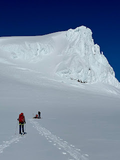
So here we find ourselves in Iceland with tales of our climb of the country's highest peak, Hvannadalshnúkur.  It is located on the southeastern part of the island, a difficult name to pronounce but thanks to the tips and experience of our seasoned guide, Einar Sigurosson, not unusually difficult to climb.  And since we climbed this volcanic peak on skis (with climbing skins affixed to the bases for the ascent) it made the decent fun and fast!  It was a long day (10 1/2 hours total up and down covering over 13 miles) but a special treat to spend it with Einar whose great grandfather in 1891 was the very first person to summit the 6,920 foot peak.  Einar also holds the record for the most successful summits of the mountain, now at 324!  When I baited the question of which of all of these times over the years was his favorite, of course he obligingly said this summit with our group!  We invited our very good friend Helga Hengge from Munich to join us on this adventure, and she is a super strong climber, not to mention witty and fun so Einar's response may not have been too far from the truth.  


We are now in the far northwestern corner of Iceland in a small village called Isafjordur where we are about to board a renovated fishing boat called the Örkin for our six day ski touring adventure in the Hornstrandir Nature Reserve.  


Tuesday, October 25, 2022

#28 Rysy, Poland High Point

Back from our Eastern Europe adventure and reporting on the third high point in three countries reached: Rysy - at 2,499 m / 8,199 feet, the highest peak in Poland. After a long but rewarding day on Gerlach we refueled with some traditional Slovakian food (and Czech beer) and headed west. As the crow flies over the High Tatras the summit of Rysy is less than three miles from the summit of Gerlach, however the best access point to the route on the Slovak side is near the ski resort town of Štrbské Pleso. From there we parked our car and hiked a little more than an hour to reach the Horsky Hotel at Popradské Pleso, set in a picture perfect scene overlooking a stunning alpine lake. 

Views along the hike to Popradské Pleso

Accommodations for two nights at Horsky Hotel at 4,900 feet
Great views of the lake and Fall colors from our room

Fortunately the weather improved for us and the forecast rain/snow and 30 mph winds did not materialize. So we left our simple but comfortable room shortly after 7:00 the next morning and made our way up the scenic trail along the valley floor. Denise endured the rocky terrain and persevered despite having tremendous ankle pain from a crampon spike scrape inflicted while climbing Gerlach two days prior. We weren't sure if she could manage the extreme discomfort throughout another long day of climbing, but her strong Polish genes and mindset from her dad's side prevailed on this Poland high point. We carefully navigated the steeper snow covered slopes high up, and appreciated the panoramas that were revealed at the ridge delineating the Slovakia / Poland border. It was less than an hour later that we found ourselves at the summit of Poland's highest peak and now our 28th country high point raising the Challenged Athletes Foundation banner. 

Combination Slovak humor and safety warning


Summit of Rysy, Poland high point on Oct. 16, 2022

...until the next adventure, all the best!

-Paul & Denise


Thursday, October 20, 2022

#27 Gerlach, Slovakia High Point

Summit of Gerlach, 2,655m / 8,709 feet Oct. 14, 2022

The High Tatras aren't as high as many mountain ranges around the world but they are certainly impressive and attract a fair number of technical climbers from around Europe. Gerlachovsky Štít is the highest in the range and rising up more than 6,000 feet above the valley floor, Gerlach is an imposing sight.

It is a requirement of the National Park to climb Gerlach with a certified guide and we were happy to do so after learning that the route high up is not marked and has some tricky exposed sections. In addition, an early season snowstorm dropped over 6 feet of snow on the mountain a week before our planned ascent, which we didn't believe until after looking at the Instagram page of our guide kuro.guide.

With the benefit of Kuro's firsthand knowledge of the conditions we came fully equipped with crampons, ice axes, climbing harnesses and helmets - and we put all of it to good use. 

Sliezsky Dom hotel, our home for 2 nights at 1,670m / 5,479 feet
Nice views on the approach hike with guide Kuro leading the way
The three of us started out from the Sliezsky Dom hotel around 7:45, and after 3,200 vertical feet of climbing we reached the top just before noon. We had the summit entirely to ourselves to enjoy the beautiful views, a snack, short rest and even reading a good book! The descent took us a little over 4 hours, getting us safely back to the trailhead and the very comfortable Sliezsky Dom less than 9 hours after we began. For the most part the weather cooperated nicely for us and the recent snow had consolidated making for stable conditions. I'll let the pictures and videos tell the rest of the story from an exciting climb of our 27th country high point!

Before I do I'll add an interesting fact about Gerlach. The mountain has the unusual distinction of being the highest peak in more countries than any other mountain. Due to the changing borders over time, since World War I it has been the highest point in Austria-Hungary, Czechoslovakia, Poland, the Czech and Slovak Socialist Republic, and then the Czech and Slovak Federated Republic, and since 1993 the highest point in Slovakia. 


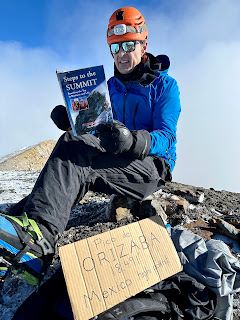
Taking a short break to read Steps to the Summit 😉

Wednesday, October 19, 2022

"Hungary" for High Points

Our quest continues to explore new countries and climb their highest peaks. This trip includes three countries and if successful three more high points adding to our 25th country high point of Portugal's Mt. Pico reached two months ago. We are also keeping a tally of countries we have visited in our lifetimes and although Denise has a few more than me, Hungary marks my 50th country. 

Budapest Parliament Building taken on Danube River cocktail cruise

After two days of soaking in the beautiful and historical sights of Buda (western part of the city) and Pest (eastern side of the Danube) we soaked in the soothing mineral waters of the Széchenyi thermal bath which is the largest medicinal bath in Europe and a famous Budapest landmark. 

Széchenyi thermal bath in Budapest: the largest medicinal bath in Europe 

The next morning we headed northeast towards the Mátra Mountains and Hungary's highest point Kékestetö aka Kekes. At only 3,327 feet above sea level with a paved road leading almost all the way to the top, we knew this high point would hardly seem like much of an accomplishment. So we decided to park the car at the bottom of the road and hiked up to the top to make ourselves feel a little better about earning this one. It also helped us stretch our legs and along with an overnight in the quaint town of Eger, it broke up the drive north across the border into Slovakia and on to the "real" mountains the High Tatras. 

Hiking up the ski slopes of Kekes, one of the few ski areas in Hungary

Kekes, highest point in Hungary at 3,327 feet